Mountain safety - safety on the Scottish Mountains
Safety First!
Make no mistake - bad choices on Ben Nevis can cost you your life!
The weather on Ben Nevis is arguably the most ferocious to be found anywhere in the UK. From hurricane-force winds of 100 mph+ to whiteout blizzard conditions, it has them all, often at the same time. The weather can also change from clear and sunny to heavy rain and driving winds with almost zero visibility within minutes and almost without warning. Even the most experienced climbers and walkers have been caught out.
Include the precipitous cliffs that Ben Nevis is famed for, the large stoney tundra of the summit and it is little wonder then, that Ben Nevis also has a reputation as a killer.
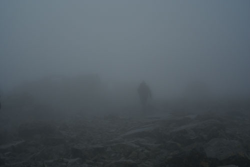
This photograph was taken in mid-July where the conditions were freezing cold, 60 mph winds, and driving, horizontal rain.
I want to climb Ben Nevis in winter wearing trainers
You're an idiot. Stay at home. Further reading: Stupidity on Ben Nevis
"I only have light clothing - is it safe to climb Ben Nevis?"
Ben Nevis is a mountain, the UK's highest, and as such is exposed to the absolute worst conditions the weather can throw at it including bone-chilling winds, sub-zero temperatures, heavy rain, snow and blizzards - sometimes all at once, therefore it is essential that anyone climbing it takes suitable precautions and dresses appropriately. Light clothing that is adequate at sea level is unlikely to provide suitable protection except on the fairest of summer days. Attempting to climb Ben Nevis without adequate protection, including waterproofs and warm clothing, could result in hypothermia and possibly death.
"I don't have a map or compass - will it be okay to climb Ben Nevis?"
The short answer is 'no.' Navigation on Ben Nevis is notoriously difficult, even for experienced walkers and climbers. Even on the best of summer days hill fog can roll in at any time to shroud the mountain and is extremely disorientating, often resulting in people walking in the wrong direction. There have, unfortunately, been deaths caused by disorientated people mistakenly following the wrong route in the fog.
There's a path - surely it is safe?
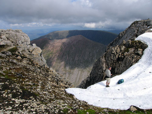
The path to the top of Ben Nevis, while well built and easy to follow in clear conditions on a summer's day, peters out near the top as a result of the rocky terrain. The route to the summit marker also passes within a few feet of the precipitous cliffs and 2,000 foot drop of the North Face. Even in mid-summer snow is often corniced and overhanging the clefts of the cliffs, meaning that the unwary could find themselves standing on nothing more than unstable snow hanging over nothing but air.
If I get into trouble surely I can phone Mountain Rescue?
Yes, of course. If you are in real difficulty you can telephone the Emergency Services, however, there is no guarantee you will get a phone signal at all as coverage on Ben Nevis is patchy or that they will be able to reach you in time. Helicopters, for example, cannot fly rescue operations in low cloud or high winds. Ground-based Mountain Rescue will do their utmost to get to you but again, even they have their limits and cannot attempt a rescue if conditions are too dangerous for them to operate. Even in ideal conditions it can take several hours for a ground-based MRT to get to your location. Often, precious time is spent pinpointing a casualty's location.
If you think there's a chance you might need to call the Emergency Services before you attempt to climb Ben Nevis then perhaps it is better to postpone it for another day?
However, should you get into genuine difficulty, do not hesitate to call them! Your phone should be kept in an inside pocket where it's warm and dry and you need to do your utmost to preserve the battery life. They may need to speak to you several times.
From Mountain Rescue
"Mountain Rescue Teams, across the UK, make use of the latest technology with the aim of pinpointing lost walkers. While they have the ability to locate smart phones with bespoke SARLOC software, this technology does rely on the availability of a data signal which, as we all know, can be unreliable in the hills and mountains of Scotland.
Therefore, in a call to all hillwalkers and mountaineers, we have decided to ask you to help us! If you own a smart phone we would like to ask you to consider installing the 'free' Ordnance Survey app OS LOCATE onto your Apple or Android phone. This simple app provides an accurate, easily readable UK Grid Reference that you can provide to the emergency operator, should you ever have to call on the services of Mountain Rescue.
At the very least, it could mean the difference between a brief spell on the hill or a cold, long wait as search teams methodically sweep mountain and glen for you. For further information please refer to www.ordnancesurvey.co.uk/shop/os-locate"
Ben Nevis Will Still Be There
Please don't allow an itinerary to overcome common sense. Ben Nevis (and other mountains) will still be there tomorrow, next week or next year. Check the forecast (including sunrise and sunset times), make certain you are properly equipped and above all, use good judgement. If you do decide to climb Ben Nevis (or any mountain) and conditions worsen you can turn around any time.
The sad story of Haider
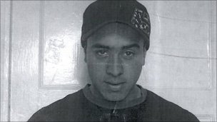
Although people die on Ben Nevis every year, the tale of Haider Ali Manir who died in January 2011, graphically illustrates how the ferocious weather on Ben Nevis (and some bad decisions) can end in tragedy.
Haider Ali Manir, 20 years-old, a civil engineering student from Worcester, decided to climb Ben Nevis with his cousin. At around 1000 metres, near the upper zigzags some 300 metres from the summit, Mr Manir's cousin decided to turn around due to the worsening conditions on the mountain.
Fatefully, Mr Manir decided to carry on despite not being properly equipped, the failing light and bitter weather.
According to the Worcester News, Mr Manir reached the summit, where, poignantly, he recorded a video stating that he had found the shelter but that he was 'in difficulty because visibility is very bad' and he 'wasn't sure where he was heading'. He chose to leave the shelter and head out into the teeth of the worsening weather, gale force winds and snow.
A few hours after the alarm was raised, the Mountain Rescue Team fought through the atrocious blizzard conditions and reached the shelter but found it empty.
Although the Search and Rescue effort eventually comprised eight recue teams including Search and Rescue Dogs Association members and helicopters from Royal Navy at HMS Gannet and the RAF at Lossiemouth, it had to be called off initially due to the appalling weather of ferocious high winds, sub-zero temperatures and blizzards with zero visibility.
Haider's body was eventually located after a five day search.