Ticking off Features
'Ticking off features' overlaps with 'Route Choice'. It is about being observant, having your map handy and checking your current position continuously as your walk progresses. When the weather is good and the skies are clear it is usually easy to check your position as you walk. When the weather is poor and visibility is limited, it may be necessary to follow a compass bearing and estimate how far you have travelled using timing or pacing.
The key skill is to keep track of where you are at all times. How do you do this? Well, it is vital to keep a constant eye on the terrain and relate this to the map as your walk progresses. You should be checking the immediate and distant terrain noting key features such as high points, crags, valleys, streams and ridges. It also helps to looking backwards to see where you've come from. All this information helps you develop a feel for the terrain around you and where you are located within it. As you pass by each feature you can 'tick it off'. This helps to re-affirm your position continuously. So, if someone were to say, "Show me where you are on the map", then you should be able to point to your location with a high degree of confidence. It goes without saying that you must have your map to hand and folded showing your route.
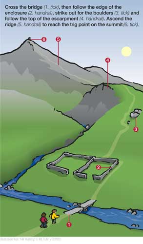
In Diagram 1 the two walkers approach and cross a bridge (tick). They then follow the edge of a sheep enclosure (tick) before striking out for the boulders (tick). From here they follow the top of the escarpment (handrail) and ascend the ridge (handrail) to reach the trig point at the summit (tick).
The key to navigating accurately is to be alert to changes in the terrain and to match these with their representations on the map. If you spot something such as a significant change in steepness and you see this reflected on the map (a narrowing of the distance between contour lines) this helps confirm your position. If you spot a feature that fails to appear on the map, then you need to be more cautious and look for other bits of information to help you decide where you are. It helps to think in terms of three different kinds of features, viz.,
i. Spot features. These are single point features such as a summit, path junction or walled enclosure.
ii. Linear features. These are anything elongated but narrow such as a path, stream or narrow ridge.
iii. Area features. These are features that do not necessarily have sharp edges such as lochs, woodland or broad cols.
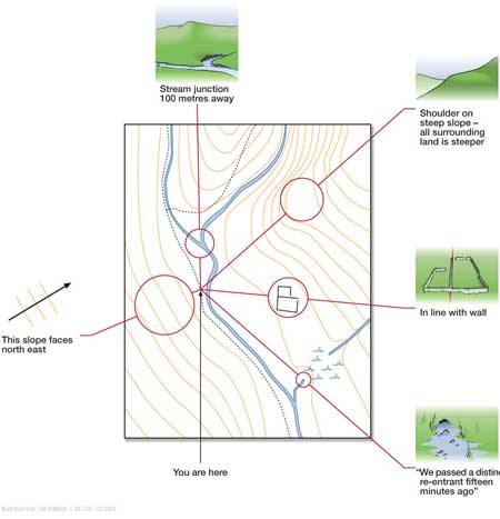
Diagram 2 shows how it is possible to gather different kinds of information to help confirm your present location.
In summary, the main thing is to observe and gather information. Look at the terrain and note how it changes as you progress. Features may appear as you gain height whilst others will disappear. The shape of the land will change as you move closer and some features may appear clearer or change in colour and texture. What you have to do is see all this on your map. If you can match 'like for like' and transfer the three-dimensional view to a two-dimensional picture then you can be confident about where you are on the map.
This page reproduced with the kind permission of the Mountaineering Council of Scotland (MCofS). They run a number of Mountain safety courses, Seminars and Lectures. You can join the MCofS here