Setting The Map
Setting the map is the technique of positioning the map so that all the features are lined up with your own location as the central point. What is in front of you on the ground will be in front of you on the map, what is to your left on the ground will also be to your left on the map and so on. The writing on the map may be upside down or sideways but this is OK - having the map set is far more useful in relating the map to the ground than being able to read the writing. View the map as a three-dimensional model which you have lined up with the features on the ground.
In good visibility you may be able to set the map by eye. If you've just set off from your car you will probably be able to set the map by using the road and another linear feature such as a path. These features will form a T-junction which can be used to set the map. A good exercise is to keep the map set with the T-junction and then move your body around the map - it is your body that moves, not the map. Once you are on the hill you will need to identify prominent features on the ground such as hills, ridges, valleys and tracks (maybe there's a village within view) and turn the map so that the features on the ground line up with you at the centre.
If identifiable features are not visible you can set the map by using the compass. Use the magnetic needle to find north and line up north on the map with north on the ground. There is no need to make any adjustments or bearings with your compass - you are just using the magnetic needle to find north. The side edges of the map will also be pointing north.
Keep the map set when you change direction. As you turn to face another direction you must also turn the map to keep it correctly set. If your body turns to the right, your hands must turn the map to the left.
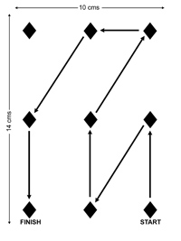
The following exercise will demonstrate the importance of setting the map and improve your skill in keeping it set. Even if you already consider yourself to be a competent "map setter" this exercise can be quite illuminating.

- Use a piece of card to draw the "map" shown in the diagram. It doesn't have to be precisely drawn - a rough job will be fine.
- Alternatively you could photocopy the diagram and stick it on a piece of card. You now have nine "features" with a route that you are going to follow.
- On a flat area of ground mark out the nine features in an oblong (use stones, drinks cans - anything that won't blow away). There needs to be about 3 metres between each marker.
- The aim of the exercise is to follow the route which you have drawn on your map. The faster you run, the harder it will be to follow the route.
- Do the first exercise WITHOUT setting the map. Hold the map against your chest fixed in front of you and don't turn it as you travel.
- Don't travel sideways or backwards (you wouldn't do this on the hill!). You will probably find it quite difficult to follow the route, especially if you run.
- Now follow the route by keeping the map set as you travel. When you change direction you must turn the map so that it stays set. You should find it fairly straightforward to follow the route, even on the run.
- Draw a different route on your map and follow it as fast as you can.
- Set this exercise up for your friends and see how they get on.
This page reproduced with the kind permission of the Mountaineering Council of Scotland (MCofS). They run a number of Mountain safety courses, Seminars and Lectures. You can join the MCofS here
