Map Scales and Distances
Because maps are representations of the land, they are smaller (obviously) than the land they represent. The relationship between distance on the ground and distance on the map is known as the scale of the map. Typically, scale is expressed as a ratio such as 1:50,000 or 1:10,000. If we take 1:50,000, this means that 1 centimetre on the map equals 50,000 centimetres (or 500 metres) on the ground. This means that the information contained in 500 metres is compacted into just 1 centimetre. Clearly there has to be a reduction in information for this to happen. The amount of information lost depends on the scale. So, a map whose scale is say 1:10,000 will contain more information than a map whose scale is 1:100,000. This is because a 1:10,000 map is physically 10 times the size of a 1:100,000 for the same area of ground.
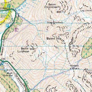
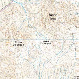
A comparison between a 1:50,000 scaled map and a 1:25,000 scaled map is shown in Diagram 1. A close examination shows the larger scale map includes more information: contours are more detailed, boulders and small rock features are included, streams, rock features are better defined and water features such as lochans and small streams are included. Note that a map which has a larger scale has a smaller ratio and vice versa. Thus a 1:10,000 map is a larger scale than a 1:100,000 map.


The key point is that scale is related to the map's use. Depending on the map's use you will need a smaller or larger scale map. If you need a greater level of detail then generally you need a larger scale map. For example, if you are seeking planning permission for a house extension you'll need a very detailed large-scale map (perhaps 1:100,000). In contrast, if you are setting out for a mountain walk then a smaller scale map will suffice. And if you are simply planning a long distance car journey across the country then an even smaller scale map (such as a standard road atlas) will be used.
The Ordnance Survey publishes maps at several different scales. Maps at 1:1,000,000 scale only show cities and major towns together with the motorway and primary route network. County boundaries are shown and are sometimes colour coded to make their shape and location clearly distinguishable. You would use this map if you needed to see the whole of Great Britain at a glance. Maps at a scale of 1:250000 show road networks, urban areas, large forests and major river networks. Road atlases typically use this scale. Maps at a scale of 1:50000 (known as Landranger maps) or 1:25,000 (known as Explorer maps) provide much more information including contours, and field boundaries etc and these are the two maps most popular with hillwalkers. Even larger scale maps at 1:10,000 provide more detail than required for mountain navigation but are commonly used, for example, by orienteers who need to understand the ground in fine detail.
Given that hillwalkers tend to use both1:50,000 and 1:25,000 maps, what are the relative benefits of each one? Basically, the 1:50,000 map tends to give a much clearer overall picture. Look at Diagram 1 again and you will see that the 1:50,000 map gives an immediate picture of the land and is less obscured with detail. The general shape of the land tends to stand out more clearly. One reason for this is that contour lines on the 1:25,000 map tend to be concealed with detail. On the other hand, because the 1:25,000 scale map provides much more information and a greater number of ground features, it provides a much more accurate representation of the ground. The advantage of this is that navigation legs can be made shorter and so navigating in difficult weather conditions should be less prone to error.
A couple of cautions. If you carry both maps and switch from one to the other there is a danger you may confuse the scale and misjudge distances. This arises because on the 1:50,000 map a distance of 1 kilometre is given by 2 cms whereas on the 1:25,000 map it is 4 cms. So for example, if you're familiar with the 1:50,000 map then moving to the 1:25,000 map could leave you overestimating distance. In other words, you may think a given leg is 1000 metres when in fact it is only 500 metres. Typically, hillwalkers use the Landranger 1:50,000 scale map most of the time and refer to the larger scale map only when conditions are more challenging as is often the case in winter.
A second problem is that for some people the extra detail provided on the1:25,000 scale map, particularly the inclusion of additional rock and water features gives the impression the ground is more hazardous than it actually is. However, this ceases to be a drawback with familiarity and practice in relating map to ground.
Basically, if you plan to use both scales then you need to develop the ability to adapt from one scale to another. This becomes especially important if you plan to use the very large scale maps available for some of the more complex mountain areas such as the summit of Ben Nevis and the Skye ridge.
This page reproduced with the kind permission of the Mountaineering Council of Scotland (MCofS). They run a number of Mountain safety courses, Seminars and Lectures. You can join the MCofS here
