Symbols and Grid References
Because a map is a scaled-down representation of the land there has to be a reduction in the amount of information it contains. It is not like a photograph that is an exact copy and consequently a wide variety of features have to be represented by a sign or symbol of one kind or another. The symbols used on maps are sometimes called conventional signs. It is unnecessary to remember every one since only a small number are relevant to walkers and in any case the symbols used by the Ordnance Survey are described on every map. On every Landranger map (1:50,000) there is a comprehensive section which gives technical information relating to north points and grid references as well as a list of symbols for rock features, water features, roads and paths and land features.
Which symbols are especially useful for hillwalkers? It helps to think of the various colours. In general, water features and their names are coloured blue, woodland and forest areas are shaded green and man-made features have a black outline. Contours which represent height are coloured brown. All of these can be seen in the map section - Diagram1.
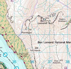
The loch to the left and the numerous rivers and streams are shaded blue - as you expect. It's worth noting that the streams are a good clue to the shape of the land. If you refer to one of the streams and the point where it starts, it follows that if you track the stream from this point then you will be travelling down the hill. It is highly unlikely that the end point of one of the blue lines is the bottom of the stream; it is invariably the starting point. Where there several streams flow into a larger river as seen to the south of Ben Lomond, then it is easy to see that this is a corrie or valley. Forest and woodland are coloured green and an example can be seen along the shore of the loch. As a hillwalker, you may wish to stay clear of green areas as walking through them is physically challenging. Navigation is also compromised because the land is hidden from view.
Black lines, which are linear, tend to represent boundaries, paths or tracks. It is vital to know the distinction between the various types of line as those representing paths and roads may provide access, where others such as regional boundaries or power lines clearly do not! A footpath can be seen on the map section running along the ridge from Sron Aonaich to the summit of Ben Lomond. It is the broken black line. Black symbols are also used to show crags and steep ground. Black, inter-linked 'curls' show both cliffs/crags and lesser outcrops. The former have a continuous line at the top (see the SE ridge of Coire Bhathaich) whilst outcrops have a continuous line at the bottom (see examples to the north of Ptarmigan). Hillwalkers need to be mindful of these features in order to identify safe routes off the mountain.
Place names and height are also given in black print and these can be a further aid to understanding the shape of the land. Spot heights tend to be given at notable high points such as knolls and summits. Names too can describe key features such as corries (e.g. Coire a Bhathaich), ridges (e.g. Sron Aonaich) and summits (e.g. Ben Lomond).
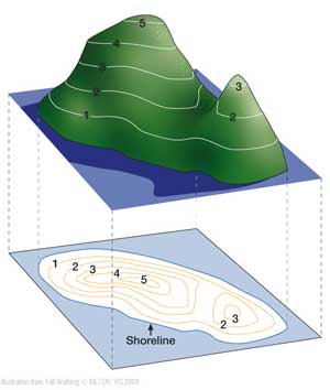
Perhaps the most important symbol is the one used to describe topography or shape of the land. This symbol is the contour. Contours are brown and show the form of the land as well as its steepness. Contours make it possible to 'see' the land in three dimensions (see Diagram 2). Any single contour is a line which connects points that are an equal height above sea level. The height interval between contours on both Landranger and Explorer OS maps is 10 metres although with Explorer maps that cover built-up areas the interval is 5 metres.
The most significant point to note for hillwalkers is that the closer together contour lines are the steeper the ground, and vice versa. Contours should always be used as a prime source of information when choosing a route. With experience, it is possible to predict the steepness of slope by looking at the contours and consequently make a judgement as to whether it is hazardous or difficult to negotiate the slope.
Grid References
All Ordnance Survey maps have a network of horizontal and vertical blue lines printed on them. Take a look at Diagram 1 again. The vertical lines run roughly north/south and the horizontal lines run roughly east/west. Lines are exactly 1 kilometre apart. The vertical lines (called the eastings) do not correspond exactly to magnetic north. The difference between magnetic north and grid north (eastings) varies across the land and also changes over time. Presently it is in the order of two or three degrees in Scotland. The exact magnitude is marked on the corner of each OS map. The grid provides a numerical system for defining a specific location. The National Grid, as it is called, was developed after the First World War by the Ordnance Survey. At one time it was thought the grid could help provide a postal code for every house in the land. The National Grid covers the entire country and is systematically broken down into smaller squares.
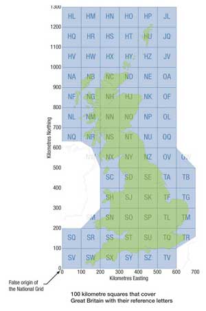
Diagram 3 shows the overall grid. Each square in the grid has sides that are 100 kilometres long. They are identified by a unique two-letter prefix. Each of these large squares is broken down further into smaller squares 1 kilometre in length. These are the squares you see on the OS map.
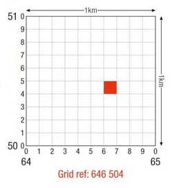
Let's take an example to show how this system can be used to identify a location. Firstly, refer to Diagram 4 and suppose you plan to climb Stob Coire a Chearcaill. This mountain is located just a few miles to the west of Fort William. It follows that you are in grid NN (look at Diagram 3 to see this). Referring once more to the map section it can be seen that the mountain lies in grid square 0172. How do we know this? Each grid line in the 100 kilometre square is given a number from 0 to 99. This is done for both the eastings and the northings. It is convention to define any single square by giving the easting value first followed by the northing value - hence in the present case, the mountain is in square 0172. More correctly, we say that the mountain lies at grid reference NN 0172. This is the four-figure grid reference and defines the location of the mountain to within an accuracy of 1 kilometre. Now, you may wish to be more precise than this. It is standard practice to go one step beyond a four-figure reference and give a six-figure grid reference. This will give an accuracy of 100 metres. What you have to do is consider how far along and how far up the mountain lies within the larger 1 kilometre square.
You need to work out how many tenths within the square the mountain lies, both to the east and to the north of the bottom left hand corner.
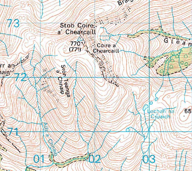
You could guess this but it is far better to use the ruler located on the side of your compass. Another way is to use the Romer on your compass to measure both distances. In the present example we determine that the summit of Stob Coire a Chearcaill is located 7 tenths along and 7 tenths up. The six-figure grid reference is therefore NN 017727. This gives the mountain's position correct to within 100 metres. In other words, the mountain lies somewhere in the 100 metre square which lies to the east and north of this point.
It is worth emphasising that a grid reference refers only to an area; it does not identify an exact position (see Diagram 5). In the example (Diagram 4) we have worked out that the mountain lies somewhere within a 100 metre square. For most situations encountered by hillwalkers this is accurate enough. However, it is worth noting that if you use a GPS receiver, a 10-figure grid reference can be recorded. This provides a location correct to within 1 metre. However, depending on the accuracy of the GPS signal, there might still be an error of around 15 metres or more. What is the value of grid references? Basically, the ability to determine grid references is a skill that could be crucial in an emergency. If you need to convey to the emergency services (Police, Mountain Rescue) where you are, then an exact grid reference may save much time in help getting to you. Grid references are also useful if you wish to leave clear information with someone about where you plan to walk. You might indicate that you plan to climb Stob Coire a Chearcaill but you can also note (perhaps on a route card) that this hill is located at NN 017727. Then, there can be no doubt about where you are going. Finally, mountain rescues teams use grid references to help helicopters identify their position speedily and accurately.
This page reproduced with the kind permission of the Mountaineering Council of Scotland (MCofS). They run a number of Mountain safety courses, Seminars and Lectures. You can join the MCofS here